

The workers of the Zone often refer to these territories as The Great Land. Not only because the way of life in Chernobyl comes with it’s own obstacles, regulations and regime, but because of the size and scale of this territory.
Check out the local geography and how not to get lost!

Let's look on the map
Let’s begin by taking a look into the actual name of the Zone, or The Zone of Exclusion and Mandatory (Unconditional) Resettlement as it is officially entitled.
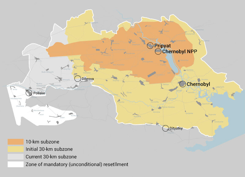
The unpopulated areas consist of two major subzones; the Exclusion Zone around 2.600 sq. kilometres which is the place we all normally mean with Chernobyl Zone, and the Zone of Mandatory resettlement of similar proportions and located to the west. They are categorized by the level of hazard within each zone.
The radiological contamination in the Exclusion Zone is varied and they are split into two subzones. The inner area of treatment for nuclear materials is the 10km zone, which the locals colloquially term desyatka. The buffer zone sits at 30 km and is known as trydcjatka.
Still used today, 10 km and 30 km zones are antiquated names that originated from the ‘80s when initial radial areas for control of fallout were marked out.
The actual shape and size of the zones are far from circular. They follow the configuration of fallout tracks as you can see on the picture below.
You can also see how the area expanded during the last three decades, after more precise analysis of contamination levels was brought into use. Initially, the most western checkpoint was Dibrova and now it takes an hour to arrive at the checkpoint Poliske by car.
What about roads?
It depends! The main highway, that connects Dityatky checkpoint and the Chernobyl Nuclear Power Plant (NPP) are in good condition. It serves a significant amount of traffic and links up villages with a fast through route. For example, it takes 30 minutes of driving to get from the checkpoint to the town of Chernobyl, and same again to the NPP. However, if we take a look on the route to Krasno Village which is the same distance from Chernobyl, it will take at least 2 hours to get there. The only way to cross the Pripyat river is via a bridge close to Chernobyl, and the road on the left bank is pure hell albeit very picturesque. In such destinations as Klyvyny village, having a bulldozer (sometimes) or at least SUV is a handy idea.
What is what in the Zone?
All together in the Exclusion Zone there are more than 90 different villages and towns. This won't be an overestimation to say that all of them are very different. Below we outlined some major locations but we are saving some places to show you when you get here in person!
Pripyat
A satellite city of Chernobyl NPP, established in 1970. Once it was a home to nearly 50,000 people. Pripyat is the perfect example of the Soviet planned cities, built according to one solid plan with a clear structure of districts. By 1986 it consisted of 5 districts and at least one more was planned for construction. Currently abandoned, except few service facilities operating.
Chernobyl
The ancient town was the former center of Chernobyl region of Kyiv oblast. The actual founding date is not known, however, first time it was mentioned in 1193. Before the disaster, this place had around 14,700 people. Currently, Chernobyl is the administrative center of the Exclusion Zone, where approximately 3,000 staff members stay and numerous facilities are in operation.
Red Forest
Approximately 6 sq. km of pine forest was extensively exposed, contaminated and eventually died. Original trees were excavated in 1987 in order to prevent secondary contamination in case of possible fires. Currently this extremely huge contaminated area is the subject of radiological studies.
Kopachi village
The year of foundation is not known, but the village of Kopachi is one of the closest to the Chernobyl NPP. Nearly completely destroyed like Yaniv and Chistogalivka, it’s wooden structures were buried in ditches. Nowadays almost nothing gives a sign that it was a home for nearly 1100 people.
Zalissa village
The biggest village of the Exclusion Zone, known at least from 1556. It is located approximately 1 km away from Chornobyl and perfectly represents its name as today it is one of the more lush settlements.
Chernobyl-2
It is one of the six components of Duga ("Arc") over-the-horizon radar complex. Designed in 1970s to detect launches of U.S. ICBMs to Soviet Union. It is a complex of more than 30 structures, the center of which is a breath taking antenna array; 148 x 500 m and 98 x 250 m. Major landmarks here are the communication center building and apartment complex, that was a home for approximately 1000 people.
As the Chernobyl disaster caused a contamination of Chernobyl-2, and then followed by the end of the Cold War seeing the collapse of the Soviet Union, the Duga project ended badly. It was cancelled and all the components were destroyed, except an array at Chernobyl-2.
Cooling pond
A giant artificial cooling reservoir, designed to cool down turbines of units I-IV of Chornobyl NPP. Historically this was a host site for a huge fish breeding facility, converted later into radiological lab, that continued operation up to the year 2000.
Cooling towers of Phase III
A complex of 2 unfinished cooling towers for Units V and VI of Chernobyl NPP. Impressive site for photography and good to see some tough hotspots.
Paryshev village
The year of foundation is unknown. This village, that had approximately 1000 inhabitants and is nearly a clean area inside the Exclusion zone. As many other villages of the left coast of Pripyat river, it features archaic architecture. Currently, it is a host of one of the forest firefighting departments and has a population of 7 families of re-settlers.
Krasno village
Ancient village, famous for its wooden church of St. Michael, built in 1800, which is a perfect example of traditional architecture of northern Polissya. This place is located on the northern contamination track, that was among the first directions of fallout.
Starosillya, Koshivka, Kryva Hora villages
Old villages at the left coast of Pripyat river, that are examples of archaic folk architecture of Ukrainian Polissa region.
Opachichi village
Relatively large and old village at the south-east of the Zone. First mentioned in 1646. Currently, few people live here, also a forest management department is located here.
Kupuvate village
For a long time this village was a site for experimental research where radiobiology studies were conducted The local traditional cemetery is definitely worth visit.
Rudnia-Veresnia
The village is named after the local river Veresnia, that crosses it and flows outside the Zone. As most of the villages are in this direction, quite a few were touched by sprawling vegetation and make it perfect for landscape photography and exploring the local houses.
Ilovnitsa
This tiny picturesque spot is located aside of the main road. Along with Rudnia-Veresnia, it is possible to see traditional architecture with some variations, specific for this part of the region.
Skazochny Pioneer Camp
Initially, this camp was built as a summer resort for kids of NPP's workers. It features the same architecture style as Pripyat. After the disaster, it became a first temporary camp for those employees of the power plant who were involved in the liquidation process.
Korogod
Great and Small Korogods make up this large village. Originating from XVII century here ayou can see a lot of houses, sometimes with well-preserved internals, as well as a quite surreal collective farming lands, and a nice cemetery.
Illyntsy
First mentioned in 1783, this village for the long time was a true gem of the Zone — as some structures there were nearly untouched. Unfortunately, few years ago it was heavily damaged by forest fires, but still there are enough locations to see. The name of the village refers to small, but powerful river Illya, that flows nearby.
Zymovysche
Wonderful, but pretty contaminated place. This village is really huge, and for long time it was an administrative center for the group of villages located on the left coast of the Pripyat river. Here was a bug collective farm, so a lot of buildings of it remained, as well as agricultural equipment of all sorts, vehicles and so on. This place borders with a railway line Semikhody - Slavutych, so sometimes one can see a passing train.
Teremtsi
A controversial place from one point of view, this village is the place where you need to go if you want to see the final stage of nature that takes over the remains of human civilization. It is located at the riverfront of the Zone. From another point of view, some parts of this place are populated and look pretty like normal village outside.
Ladyzhychi
In our opinion, it is an unusual place. This village, known at least from XVII century, consists of few parts, that differ from each other very much. One is in a pine forest, another is between swamps and fields, and third one is in a dense forest. A good place to explore houses (some of them have quite good condition inside), take pictures and walk around.
Poliske
The easiest way to describe this town is to say 'Abandoned version of the town of Chernobyl'. This place has long and hard history — being established at around 1215, it survived multiple wars, changes of states, periods of economic rise and fall. The soviet rule was a disaster to the town — in the beginning it degraded from a developed industrial settlement to nearly completely agriculture-specialized village. After establishing the Zone in 1986, Polisske was yet not included into it. It became one of the main evacuation points after disaster; moreover, a lot of investments were completed years after. However it soon became evident that this area was also contaminated. In 1993 Poliske was evacuated.